Ferries, at least 93 of them since the mid-1800s, used to cross the Columbia River everywhere the landscape allowed a good launch site. Now, there are just three Columbia River ferries, two on Lake Roosevelt. The Columbian Princess runs between Gifford and Inchelium, 60 miles upstream from the other, the Keller Ferry, where the Sanpoil River enters the Columbia. These two ferries are free.
Passengers pay to ride a Columbia River ferry that runs between Washington and Oregon about 30 miles upstream from the Pacific Ocean.
The other ferries were displaced by 11 dams that left their landings underwater, and 22 bridges that provide unrestricted crossing.
This is by no means a comprehensive account of the many crossings of the river. One of the great things about this format is the ability to go back at any time to make additions and corrections.
Northport Ferry

This early ferry was a catamaran cable ferry. The Columbia & Red Mountain Railway Bridge can be seen in the background. Ed S. Adams began ferry service in 1892, the year Spokane Falls & Northern reached Northport. Because the west landing was on the Colville Indian Reservation it was necessary to obtain permission from the Indian Office for a ferry. Others applied, but D. C. Corbin, building the railroad, spoke to the Indian agent on behalf of Adams. Although licensed, Adams was heavily in debt and sold out to Eber C. Smith and a Mr. Ogilve. Chief Maltheros, whose people operated a ferry at Little Dalles, not wanting whites doing business, threatened the ferrymen at Northport, but the agent quieted the fuss.

Columbia & Red Mountain Railway Bridge

The Le Roi mine in Rossland, British Columbia, was the site of a big copper strike of 1892. Spokane shortline baron Daniel C. Corbin proposed building the Columbia & Red Mountain Railway, a seventeen mile branch line from Rossland which would connect with the Spokane Falls & Northern’s mainline at Northport, Washington, where a smelter would be constructed. It took Corbin nearly three years to obtain the necessary charters and financing to begin construction. In the meantime ore from Rossland was carried by horse drawn wagons down the Sheep Creek trail to the Columbia and ferried across to the Spokane Falls & Northern. Construction of the Columbia & Red Mountain began in May of 1895 and was completed on December 10, 1896. Cars of the Columbia and Red Mountain were ferried across the Columbia until the Northport Bridge was completed a year later.
A contract for construction of the Columbia & Red Mountain Railway’s Northport Bridge was awarded to the San Francisco Bridge Company on January 15, 1897. Work on the piers and abutments began immediately after legislation allowing construction of the bridge was signed into law by President McKinley on January 27th. There was a contractual obligation to complete the structure in five months. The bridge builder’s luck ran out in May when high waters swept the falsework out from under two partially completed spans and all work had to be suspended until the next low water period in September. The crossing opened on October 12, 1897. As reported in the Spokane Spokesman Review:
“Amid the strains of the Northport band and the tooting of whistles, the big bridge over the Columbia river carrying the Red Mountain tracks to Rossland was tested and opened for traffic yesterday afternoon. The bridge was tried by backing three loaded coal cars and four flat cars of stone pushed by the 100 ton engine, No. 3, over to the reservation side. The engines then returned, and later in the evening the freight train from Rossland came direct into the yard over the new bridge. The passenger train from Rossland today came in on time, leaving Rossland half an hour later than hitherto, owing to the saving in time of the bridge over the ferry…”

being condemned on January 27, 1947. Construction of a new highway bridge took four years and was plagued by the same ice and flooding problems encountered by the builders of the original Red Mountain bridge. Cars and trucks made the Northport crossing on a state operated ferry during this period. Several spans of the old bridge, no longer able to support their own dead weight, collapsed and fell into the river with a thunderous crash before the remains of the structure were finally demolished in 1950.

Northport Bridge
The present steel cantilever through-truss bridge replaced the 1897 timber bridge, and was opened in 1951. It carries Washington State Route 25. It is one of a series of similar bridges built at about the same time, including the Grand Coulee Bridge and the Kettle Falls Bridges. The bridge was designed by George Stevens of the Washington State Highways, and the main span was built by the Midland Structural Steel Company. Work began in August 1946. Floods in 1948 undermined the south main pier of the steel structure, causing the design to be changed from a section of earth fill to five additional T-beam concrete approach spans. Underwater blasting was required to remove the south pier for the altered work, resulting in a 673-foot (205 m) series of concrete approach spans on the south. The Northport Bridge was placed on the National Register of Historic Places on May 24, 1995.


Between Northport and Kettle Falls are several places of interest, about which I may add pictures and further information, including the following:
Little Dalles, 5.65 miles downstream from Northport
China Bend
Marble 7.45 m. from Northport
Ryan 12 m. from Northport
Bossburg 16.9 m. from Northport
Evans 22.3 m. from Northport
Marcus 25 m. from Northport
Kettle Falls
 |
| Kettle Falls before 1904 |
 |
| Kettle Falls on the Columbia River, Stevens County, Washington ca. 1910s - Picturesque view of Kettle Falls. The backs of some people looking at the Falls can be seen in the foreground. (University of WA Libraries Special Collections/ Northwest Museum of Arts and Culture/ L94-40.51) |
 |
| New highway bridge and railroad trestle at Kettle Falls, WA in 1941. Seen to the far left of them is the old 1929 steel deck truss that was being replaced and and removed. The new bridges were built higher to accomodate the rise of the Columbia River that was to occur as Lake Roosevelt was formed behind Grand Coulee Dam (the old bridge would have been partially submerged). |

 |
| OBLIQUE PERSPECTIVE OF EASTERN PORTALS OF HIGHWAY AND RAILROAD SPANS Columbia River Bridge at Kettle Falls, U.S. Route 395 spanning Columbia River, Kettle Falls Stevens County, WA; Historic American Engineering Record, creator, 1993 Library of Congress Call Number: HAER WASH,33-KETFA.V,2- |
This bridge was one of two steel cantilever spans that the Washington Department of Highways constructed to replace structures flooded by the waters rising behind Grand Coulee Dam. The Columbia River Bridge at Kettle Falls with its 600' steel-truss cantilevered and suspended structure has the longest central span of any highway bridge built in the state of Washington in the 1940s. Construction of this structure and the Spokane River Bridge at Fort Spokane were financed by the United States Bureau of Reclamation, as part of a highway relocation program in conjunction with the Grand Coulee Dam Columbia Basin Reclamation Project. The dam's construction raised the Columbia River, creating the Franklin D. Roosevelt Lake. The reservoir's formation necessitated replacing the two highway bridges and one railroad structure. The bridges were added to the National Registry of Historic Places in 1995.
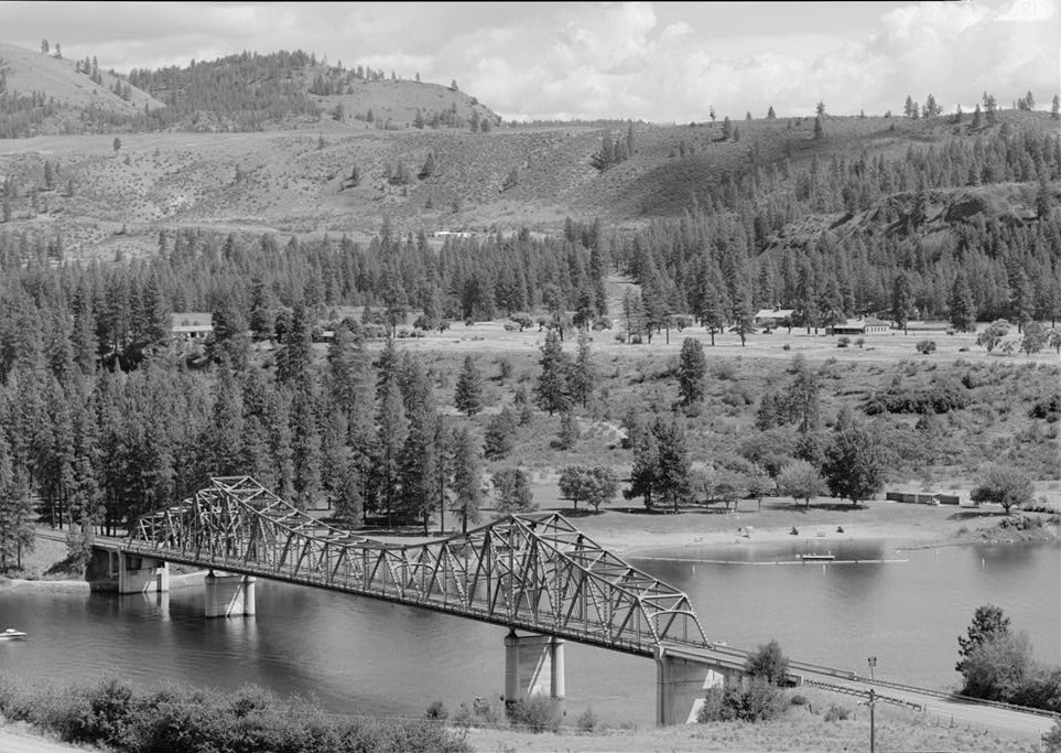
Inchelium-Gifford Ferry
 |
| Gifford-Inchelium Ferry traveling across the Columbia River ca. 1930. Photo and information courtesy of Crossroad Archives/Stevens County Historical Society |
 |
| Early cable ferry across Columbia River at Inchelium UW Special Collections (L97-26.159), no date |
The crossing was made by a cable ferry until 1938 when completion of Grand Coulee Dam widened the river, slowed its current and made operation of that type of vessel impractical. The barge was freed from her cable and pushed across the river by a tug until a diesel powered ferryboat, the first of two named Miss Columbia, could be built in 1941. The old landings lie ninety feet under water.
 |
| MISS COLUMBIA, powered by two GMC Diesel engins, glides between Gifford and Inchelium date and photographer unknown |
 |
| Columbian Princess, 12 March 2007 JStripes at English Wikipedia [CC BY 2.5 (https://creativecommons.org/licenses/by/2.5)] |
The Columbian Princess began operating on the crossing in 1983. The 16-car vessel, owned by the Bureau of Indian Affairs, was operated by Columbia Navigation Inc. until 1994, when the Colville Confederated Tribes took over the contract under a law that encourages tribes to run federally funded ventures that serve reservations.
Downriver some five miles (a mile north of Bissel) John McGrath began ferry operations when the South Half of the Colville Reservation was opened for mineral entry. McGrath ferried supplies for Covada, a mining community named with the first letters from the Columbia, Otin, Vernie, Ada, Dora, and Alice mines. S. A. Oens took over the ferry in 1909, the year a cowboy heavily loaded with chaps and big guns was kicked into the river by a horse.
FORT SPOKANE
 |
| SPOKANE RIVER BRIDGE FROM NORTH BANK OF RIVER, FORT SPOKANE IN BACKGROUND Spokane River Bridge at Fort Spokane, Spanning Spokane River at State Route 25, Miles, Lincoln County, WA; Historic American Engineering Record, creator, 1993 Library of Congress Call Number: HAER WASH,22-MILES,1--3 |
This bridge near the mouth of the Spokane River was one of two steel cantilever spans that the Washington Department of Highways constructed to replace structures flooded by the waters rising behind Grand Coulee Dam. The Spokane River Bridge at Fort Spokane is the largest bridge constructed in Washington in the 1940s before American involvement in World War II precluded bridge building. Financed by the United States Bureau of Reclamation, along with one other highway structure, the Columbia River Bridge at Kettle Falls, was part of a highway relocation program in conjunction with the Grand Coulee Dam Columbia Basin Reclamation Project. The dam raised the Columbia River and tributaries including the Spokane River, creating the 151-mile-long Franklin D. Roosevelt Lake. The reservoir's formation necessitated replacing the two highway bridges and one railroad structure. The cantilever design used for the Spokane River Bridge at Fort Spokane was the most economical type of bridge for the location because the river's depth even prior to the dam's construction precluded using any design that required mid-channel falsework.
Stimson's Ferry

Creston Crossing
 |
| The ferry Peasley bought from the businessmen |
 |
| Barge formerly owned by Luther Stimson, 1908 |
Hellgate
 |
| Hellgate region of the Columbia River, Washington, ca. 1908. https://digitalcollections.lib.washington.edu/digital/collection/loc/id/1098/ |

The Hellgate Ferry was owned first in 1927 by Ernest Redford, then two years later by Bramlet Flannigan before Ferry County maintained a donated ferry. Creed Thomas began a ferry here in 1910. He kept a small store along with an orchard and berry farm. Before him, C. S. Scheibner, who logged and milled lumber on the Colville Indian Reservation, ran a ferry located upstream. Indian Moi-yan ran a row ferry four miles upriver from Hellgate Rapids at the beginning of the twentieth century. There was a large San Poil Indian village on the right bank (Lincoln County side) at thee time. Indians here were called the Whitestone Indians for a large rock bluff nearby. In the 1870s, Herman Joseph Friedlander ran a store for Indians ferrying the Columbia to his establishment on the right bank (Ferry County side).

Fred and Otto Rothlisberg's lambing crew rests on the Hellgate ferry after its carto of lambs has been offloaded. The Rothlisbergs provided a ferry barge and launch from 1930 to 1939. Ferry County maintained the operations for the few people in the southern end of the county without easy access across the river. To those utilizing it, the ferry was of great importance. Mail was crossed twice weelly in good weather and once weekly in winter.
Henry Covington
 |
| Henry Covington spearing salmon on the Columbia at the mouth of the Sanpoil River, circa 1910 |
The steamer Victory, piloted by Henry’s father “Virginia” Bill Covington, began operating in competition with the cable ferry in 1900 but the service lasted only a year because of problems with the craft’s mechanical systems.
Keller Ferry
John Christopher (J.C.) Keller was born in Cincinnati, Ohio, October 16, 1858, and came west in 1882. He conducted the post office and a general store at Hesseltine, northwest of Wilbur and when the railroad built to Davenport, Mr. Keller moved to Almira and opened a mercantile store. In 1897, anticipation of the opening of the Colville Reservation South Half to mineral entry prompted him to buy the cable ferry across the Columbia to the San Poil, which then became known as the Keller Ferry. He opened a store near there the next year. He later opened a store at Omega or Eureka, now known as Republic. He ran a pack train up the San Poil River and later built a road along the river from the Columbia to Republic. He owned the ferry until Ferry County took over on December 9, 1926, after which he moved to Spokane, where he died April 25, 1929. His daughter, Lula, married my father's cousin, Gordon Poston.
 |
| Left: Keller Ferry, early 1900s. Right: J.C. Keller and his wife Amelia, in Spokane. Family photos from J.C. Keller's great-granddaughter, Holly Evans, my paternal second cousin once removed. |
 |
| Keller Ferry in 1936 from Ed Powell collection |
In 2013 the Washington Department of Transportation launched the Sanpoil, a 20-car ferry built to replace the Martha S, a six-car ferry that had covered the mile-long route across the Columbia River north of Wilbur for 64 years. The Marha S made it's last run on Sunday, July 7.
My maternal great-grandfather, Tom Seaton, conducted the Hesseltine post office and store for a few years after he came west from Missouri in 1889, and moved down to Plum to start his ferry about 1897, also because of the South Half opening.
________
To be continued
________
Related Video
Echoes of Yesterday
Here is part of the untold story of Grand Coulee Dam and Lake Roosevelt: With the Construction of Grand Coulee Dam came the creation of Lake Roosevelt, these backwaters of 180 miles lay from Central Washington up to the Canadian Border. Grand Coulee is used for Hydro Electricity, Flood Control, Barging, Irrigation that changed 600,000 acres of desert to productive farm ground and with many more local and federal benefits. This story tells of only a portion of what the negative impacts inflicted upon the Native American tribes of this area so all others could benefit as the land was taken and flooded, lands that at one time were sacred fishing sites, home sites, river bottom lands used for towns,farming and orchards. This video tells of the attempt to relocate the ancient graves of the people that lived here since time in immemorial by Ball and Dodd funeral home. Today the Colville Tribe receives compensation from the their lands used for water storage; the Spokane Tribe continues to seek the same consideration for its lands used for water storage by Congress and the United States.
A River of Promises
Impacts to the Spokane Tribe caused by the building of Grand Coulee Dam and the injustice as Spokane Tribal lands continue to be used to store water without compensation.
________
Sources
(to be added)
Thomas Stensgar, of the Hudson's Bay Company, died on August 15, 1891. he could not have established the Inchelium-Gifford Ferry in 1898.
ReplyDelete