Monday, November 28, 2011

LILLQUIST, Chapter II, pt. 1

________________________

Chapter I.        Table of Contents        Chapter II, pt. 2
________________________

5


CHAPTER II

COULEE CITY AND GEOLOGICAL CHARACTERISTICS

OF THE BIG BEND

Location

     Coulee City, Washington, is a small rural farm community located 100 miles west of Spokane on U. S. Highway 2 near the junction of State Highway 17.  The town is situated on an alkali flat at the south end of Banks Lake, a 25-mile long man-made reservoir that covers the floor of the upper Grand Coulee.  The South Dam that forms the southwest end of the reservoir, extends in a westerly direction from the outskirts of Coulee City.  Coulee City is the oldest town in Grant County.  The name is apparent because of the location at the middle crossing of the Grand Coulee. 1  This middle crossing of the Grand Coulee is situated at the center of the upper part of the Columbia Plateau that has been called the Big Bend country.

      The two major cross-state highways that intersect two miles west of Coulee city give some insight into the significance of the location of Coulee City.  U. S. Highway 2 is a main route of travel west from Spokane to Wenatchee across the Big Bend.  State Highway 17 is the principal north-south route of travel from Pasco to the Okanogan Valley.
____________

1  Edmond S. Meany, Origin of Washington Geographic Names (Seattle: University of Washington Press, 1923), p. 58

________________________

6

Fig. 2 -- Location of Coulee City


Google Maps

________________________

7

      The Two most significant geological features of the region around Coulee City are the Grand Coulee and Dry Falls.  These two scenic wonders of nature attract thousands of tourists each year.  In 1967 the car count of visitors to Dry Falls numbered 468,854; July was the largest month, having a total of 107,044. 2
Other Geological features that attract interest are the talus slopes, basaltic columns, monoclines, caves, lava strata, and haystack rocks.  Each of these features shows evidence of the great geological changes that the area has experienced during the past 20 million years.  For one to try to understand this geology it is necessary to go back about 20 million years when the landscape of central Washington consisted of mountains, valleys, streams, and lakes.  The sequoia, oak, elm, cypress, chestnut, and sacred ginkgo grew over what is now the Columbia Basin.  This growth took place during the Miocene period of the geological time scale. 3

Geological Change

      At the close of the Miocene period and during the early Pliocene that followed, a great basaltic lava flood engulfed approximately 250,000 square miles of the Pacific Northwest.  For perhaps 10 to 15 million years a succession of lava floods poured out over the granite base rock from fissures or cracks in the earth's crust. 4  Eventually this lava accumulated a thickness
____________

2  This information was obtained from the ranger at Sun Lakes Park in 1968.

3  This information was obtained from a pictorial display at Ginkgo State Park, Vantage, Washington.

4  Joseph G. McMacken, Geology of the Grand Coulee and the Columbia Basin Project (Spokane: Joseph G. McMacken, 1937), p. 3

________________________

8

of over 4,000 feet in places, and a large depressed lava plain, now known as the Columbia Plateau was formed. 5  The flood of lava appears to have advanced in a northeasterly direction forcing the Columbia River into its present course between the plateau and the granite mountains of the Okanogan Highlands.  The lava floods impounded ancient lake beds where fossil leaf impressions, petrified wood, and fossils are found today.  One of the most unusual fossils to be found was the Blue Lake Rhino that was discovered in a cave near Blue Lake on July 10, 1935. 6

      The weight of the lava and other forces deep within the earth have warped the plateau in several places, causing the plateau to tilt slightly to the south.  This tilting resulted in a series of stairstep rockfolds, called monoclines, in the vicinity of Coulee City and Soap Lake.  Following the Pliocene Era and about 1,000,000 years ago, the earth began to experience a cooling trend, which was favorable for the creation of great sheets of ice.  during the Pleistocene Era or the Ice Age, scientists estimate that about one-third of the earth's surface was covered by ice.  As the snowfall exceeded melting and evaporation, the glaciers started pushing southward out of present-day Canada and blocked the Columbia River near the present site of grand Coulee Dam.  The river changed its course when the water that backed up behind the ice jam spilled out across the
____________

5  Editorial Staff, "Grand Coulee Country," Sunset Discovery Trips in Washington (Menlo Park, Calif.: Lane Publishing Co., 1956), p. 85

6  Coulee City Dispatch, August 22, 1935, p. 1

________________________

9

sloping lava plateaus and ultimately, by following the lines of least resistance, formed the coulees which characterize the region today. 7 *

      This glacial river carried a great deal of sediment that gave erosive power as the gradient was somewhere between 20 and 30 feet per mile. 8  Many of the eroded materials were dropped by the flood waters and later helped to form the fertile soils of the Quincy Basin.

Dry Falls and the Grand Coulee

      The largest of the coulees and the one that was the main stream bed is the Grand Coulee.  As the Columbia moved along southward, two major cataracts were formed along its course.  One of these was north of Coulee City in the vicinity of Steamboat Rock and the other was south near Blue Lake.  The larger cataract was in the upper coulee, but Dry Falls in the lower coulee has become the most famous tourist attraction.  Here the tremendous erosive power of the current caused the basaltic layers to wear away and the falls retreated to its present location four miles west of Coulee City.  Dry Falls is three and one-half miles wide with a drop of 400 feet, making it the greatest waterfall skeleton in geologic history. 9

     The Coulee walls show evidence of at least seven major lava floods separated by intervals of time.  McMacken points out
____________

7  Information obtained from the pictorial display at the Dry Falls Museum, Coulee City, Washington.

*  More recent scientific investigation points to ice age floods from a glacial Lake Missoula as what carved out the Grand Coulee.  At PBS.org, Mystery of the MEGAFLOOD provides links to much more information.  The Cheney-Spokane Chapter of the Ice Age Floods Institute includes pictures and information on the Big Bend and Grand Coulee area.

8  McMacken, p. 5

9  Information obtained from the pictorial display at the Dry Falls Museum.
________________________

10


Dry Falls


Air View of Dry Falls

The Upper Grand Coulee


Coulee Monocline


________________________

11

that there is evidence that the Columbia was dammed again at a later date by the okanogan Lobe of the Wisconsin Glacier, causing the Grand Coulee to experience more erosive power of glacial water that deepened the Coulee 50 feet or more. 10  Hodge, in his paper Origin of the Washington Scablands, tends to support McMacken's theory. 11  Southwest of Coulee City extend a series of eroded coulees that J. Harlen Bretz named scablands.  He defines these coulees as "a multiplicity of irregular and commonly anastomosing channels and rock-basins eroded in basalt containing meadows, swamps and lakes." 12  These scabland channels are abandoned glacial spillways of the Columbia as it cut its way across the plateau.  The plateau to the west of the Grand Coulee was glaciated to the edge of the Coulee during the Wisconsin Epoch.  After the retreeat of the glacier large haystack rocks were left as evidence of the glacier's passing. 13.

      During the latter part of the Pleistocene Era the climate moderated and the ice slowly retreeated northward, causing the ice dam to disintegrate and allow the columbia to return to its original channel along the northern edge of the lava plateau.
____________

10  McMacken, p. 12

11  Edwin T. Hodge, "Origin of the Washington Scablands," Northwest Science, VIII (September, 1934), 9-10.

12  J. Harlen Bretz, "Glacial Drainage on the Columbia Plateau," Bulletin of the Geological Society of America, XXXIV (September, 1913), 591

Also, Otis W. Freeman, Howard H. Martin, The Pacific Northwest:  A Regional, Human, and Economic Survey of resources and Development (New York: John Wiley and Sons, Inc., 1942), pp. 63-64.

13  Ibid., p. 62.

________________________

12

The river bed was left high and dry to become the largest abandoned river channel in the lava plateau of eastern Washington and represents the greatest example of canyon excavation by glacial waters in existence.  The Grand Coulee is one  and one-half miles wide at the south end and four miles wide at the north end, according to information obtained from the earliest geoligical survey made of the Coulee in 1892. 14  Jones wrote that "in comparison to the time it took nature to do this work, a man's life is no more than the whispering of a breeze along these canyon walls." 15  See Appendix A for geologic time scale.

      In searching for the origin of the name Grand Coulee, one finds two different definitions.  jones, in his Evergreen Land, claims that Coulee is a French word meaning a deep dry river bed of lava rock. 16  Hawthorne, in History of Washington, says that "Coulee is a term corrupted from the French word 'Couler,' meaning a cut off." 17  Meany, in his Origin of Washington Geographic Names, does not define the term Grand Coulee.  He mentions that the name appeared in literature regarding the area as Grand Coolly in 1825 and Grande Coulle in 1841. 18
____________

14  Israel C. Russell, "A Geological Reconnaissance in Central Washington," Bulletin of the U. S. Geological Survey, No. 108 (Washington, D. C.: U. S. Government Printing Office, 1893), p. 90.

15  Nard Jones, Evergreen Land (New York: Dodd, Mead and Company, 1947), p. 57.

16  Ibid., p. 58.

17  Julian Hawthorn (ed.), History of Washington, Vol. II (New York: American Historical Publishing Co., 1893), p. 202.

18  Meany, p. 100.

________________________

13

Alexander Ross labeled this chasm as the Grand Coulee in 1814. 19  On an 1838 map showing the important fur trading posts in the Oregon Country the chasm is called the Gr. Coallee.

      The Coulee is divided into an upper and lower coulee by a break in the canyon walls at Coulee City.  This break is represented by the two monoclines located near Coulee City --  one lying four miles north along the east wall of the coulee; the other, four miles west where U. S. Highway 2 climbs up the west wall on its route to Waterville.  these monoclines form a sag in the coulee walls that provide the only place within 60 miles where the Grand Coulee can be crossed without great difficulty.  This break provides a route which people have travelled since primitive man moved across the Big Bend Country.
____________

19  Alexander Ross, The Fur Hunters of the Far West, ed. Kenneth A. Spalding (Norman: University of Oklahoma Press, 1953), pp. 31-32.

________________________

Chapter I.        Table of Contents        Chapter II, pt. 2
________________________


________________________

(page 11 is fig. 2, above)
________________________


________________________


________________________


________________________


(page 10 is fig 3, above)

________________________


________________________


________________________


________________________

Saturday, November 26, 2011

LILLQUIST, Chapter I

________________________

 ________________________

1


INTRODUCTION

     There are a number of reasons why I have attempted to write a history of Coulee City, Washington.  Having lived in the Grand Coulee region for the past 32 years, I have developed a strong feeling for the rugged beauty of the Coulee walls.  I am most appreciative of the healthful climate and the opportunities that exist for outdoor recreation.  During the past 15 years of my employment in the Coulee City School System I have had an opportunity to know and work with many good people.  Their support and friendship has been most gratifying to me and my family.  Many of these people have lived their entire lives in the Coulee country of eastern Washington.  While some are now past the three-quarter century mark in age, they still have a straight back, clear eyes, and a wonderful memory.  I admire these people who could neither be discouraged by hardships nor deterred by disaster.  They have remained through good times and bad, raised their families and worked to develop their homes and community.  Through it all they have retained two important characteristics -- a sense of civic responsibility and a sense of humor.

     Having developed a natural interest in geography, history, and anthropology I feel that there is a great need to write an account of Coulee City and its surrounding area.

________________________

2

Eventually the people who have helped make the history of this community will no longer be part of the scene.  Each winter a few old timers are lost and soon no one will be around to relate the experiences and keep the records straight.  To my knowledge there is no complete history of Coulee City in existence.  Much that has been written about the region is fragmentary and bears on the romantic interest of a wild west frontier town.

     I realize that no history is ever complete and I hope that my efforts may encourage someone to come forward in the future and write a more complete account before the story of the region becomes a dim light in the past and is entirely lost to posterity.

     In order to clarify two terms in the narrative the following deffinitions are used:

     Big Bend. -- All the region in the Big Bend of the Columbia, from the Snake River to the mouth of the Spokane River, lying west of the Palouse and Spokane country,a nd embracing the present counties of Franklin, Adams, Lincoln, Grant, and Douglas in the State of Washington. 1

     Inland Empire. -- A popular and local name used to describe the region of the northwestern United States  between the Rocky Mountains and the Cascade Mountains, embracing large portions of eastern Washington, northeastern Oregon, northern Idaho, and western Montana. 2

____________

     1  William S. Lewis, Early Days in the Big Bend Country (Spokane: W. D. Allen, 1926), p. 3

     2  Johnson E. Fairchild, "The Inland Empire," Colliers Encyclopedia, XIII (New York: Crowell-Collier Educational Corporation, 1968), 21.

________________________

3

     In the following text I will give an account of the natural setting of the Grand Coulee and Coulee City.  Information will be given concerning the Indians of the area, and the early history of the region as it passed through the various stages of development.  The first white men in the area were associated with the fur trade; they were followed by people who were involved in making a survey or exploration of eastern Washington and who noticed and wrote briefly about the Grand Coulee and its wonders.  People who passed through the region in the gold rush era noticed desirable characteristics that later encouraged them to return and settle the land.  With the coming of the railroad to the Pacific Northwest, the Columbia region became the last frontier--a place to start a new life.  Big Bend pioneers can be called the last representatives of the great pioneer movement which had crossed the American continent. The appeal of free or cheap land teeming with opportunity, and the chance to better themselves drew an increasing number of people into the region.  I hope to shed some light on the economy, growth, and life of Coulee City from 1890 to 1925 in this chronologically arranged account.
     While many of these pioneers themselves never came into full enjoyment of the prosperity in the Big Bend Country, many of their children and grandchildren have,.  Hopefully, this history will make the younger generation more appreciative of the efforts of their forebearers.

________________________

4


Fig. 1. -- Map Showing the Big Bend Country


Google Maps Satellite view C. S.


________________________

________________________


________________________

________________________

________________________

(page 4 is Fig. 1, above)
________________________

________________________


Friday, November 25, 2011

LILLQUIST HISTORY OF COULEE CITY

Title Page, Acknowledgments, Table of Contents

     It is a great privilege to be able to publish Mr. Lillquist's work in this blog.  I am grateful for his permission to do so.  Thanks are also due to Nick Thiry for staying up late one night to scan all 140 pages and send them to me by Email in PDF files, and to Harold Evans for the loan of his copy of Les' book to Nick.  When I began this blog at the end of 2010, I had no idea where it would take me; certainly not to the publication of this work, which I would not even have known about without the "You're probably from Coulee City if..." Facebook group started by Conor Jorgensen.  Web format is a little different from manuscript or book format: In the transcription all page numbers are at the top of each page; in the Table of Contents, the page number is at the beginning rather than at the end of each line.  I have also included links to related information from other sources or from other posts in this blog, and pictures from other sources, and hope add more in the future.  Pictures of the pages from the manuscript appear at the end of each post. - C. S.

      Mr. Leslie E. Lillquist, 80, passed away Sunday, July 15, 2012, at St. Joseph Medical Center in Bellingham, Washington.  He had been living in La Conner. An obituary was published by The Star (Grand Coulee) on August 1.

________________________

i


A HISTORY OF COULEE CITY, WASHINGTON

By

LESLIE EDWIN LILLQUIST


A special problem submitted in partial fulfillment of the
requirements for the degree of

MASTER OF ARTS IN THE TEACHING OF SOCIAL STUDIES


WASHINGTON STATE UNIVERSITY
Department of History

1969

________________________

ii

ACKNOWLEDGMENTS

     I wish to express my gratitude to the citizens of Coulee City for their help and kindness.  These people granted audiences for interviews and gave freely of their time and information.  Their names are listed in the Bibliography.  My further thanks are extended to staff members of libraries, of newspapers, of the Grant County Court House, and of the Grant County Public Utility District.  They were most helpful and courteous in providing materials for this study.
     I would like to thank Dr. George Frykman for his help and guidance.  To my friend Gordon Peterson I extend my sincere appreciation for help in correcting my manuscript.  A special thanks is extended to my wife for her support and encouragement while working on this project.

________________________

iii

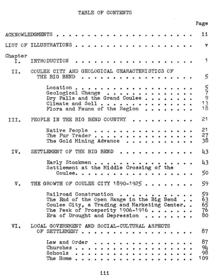
TABLE OF CONTENTS

    ii     ACKNOWLEDGMENTS

    v     LIST OF ILLUSTRATIONS

    1     Chapter I.   INTRODUCTION
    4                  Fig. 1.  Map Showing the Big Bend Country

    5     Chapter II, pt. 1   COULEE CITY AND GEOLOGICAL CHARACTERISTICS OF THE BIG BEND
    5                  Location
    6                  Fig. 2.  Location of Coulee City in Relation to the State of Washington
    7                  Geological Change
    9                  Dry Falls and the Grand Coulee
  10                  Fig. 3.  Geology of the Grand Coulee
           Chapter II, pt. 2
  13                  Climate and Soil
  14                  Fig. 4.  The Location of Coulee City in Relation to the Grand Coulee and the Middle
Crossing of the Coulee
  15                  Fig. 5.  Coulee City, Washington
  18                  Flora and Fauna of the Region

  21     Chapter III, pt. 1    PEOPLE IN THE BIG BEND COUNTRY
  21                  Native People
  24                  Fig. 6.  Map Showing the Tribal Distribution of the Indians in the Vicinity of Coulee
City and the Grand Coulee
  25                  Fig. 7.  Indian Artifacts

           Chapter III, pt. 2
  27                  The Fur Trader

           Chapter III, pt. 3
  38                 The Gold Mining Advance
  42                  Fig. 8.  Roads and Trails through the Big Bend at the Time of the Mining Advance

  43     Chapter IV, pt. 1    SETTLEMENT OF THE BIG BEND
  43                  Early Stockmen
  47                  Fig. 9.  Map Showing where the Early Stockmen Located in the Big Bend

           Chapter IV, pt. 2
  50                  Settlement at the Middle Crossing of the Coulee
  52                  Fig. 10.  Homesteaders' Cabins
  57                  Fig. 11.  Early Home Sites

  59     Chapter V, pt. 1     THE GROWTH OF COULEE CITY  1890-1925
  59                  Railroad Construction
  63                  The End of the Open Range in the Big Bend

           Chapter V, pt. 2
  65                  Coulee City, a Trading and Marketing Center
  66                  Fig. 12.  Coulee City in 1900
  72                  Fig. 13.  Early Buildings in Coulee City

           Chapter V, pt. 3
  76                  The Peak of Prosperity 1906-1916
  80                  Era of Drought and Depression
  81                  Fig. 14.  Harvest Scenes in the Big Bend

  87     Chapter VI, pt. 1    LOCAL GOVERNMENT AND SOCIAL-CULTURAL ASPECTS OF SETTLEMENT
  87                  Law and Order
  94                  Churches

           Chapter VI, pt. 2
  98                  Schools
  99                  Fig. 15.  Senior Citizens
101                  Fig. 16.  Historic Sites

           Chapter VI pt. 3
109                  The Home
________________________

iv

117     BIBLIOGRAPHY


           APPENDIX
124     A.   CALIBRATED GEOLOGIC TIME SCALE
125     B.   STATE HIGHWAYS AND RAILROADS IN GRANT COUNTY
126     C.   NUMBER OF FARMS IN WASHINGTON FROM 1890-1920
128     D.   PLAT OF COULEE CITY TOWNSITE 1916
130     E.   COULEE CITY BUSINESS ESTABLISHMENTS 1916-1917
132     F.   COULEE CITY HIGH SCHOOL GRADUATES 1912-1925
133     G   THE 1916 COULEE CITY SCHOOL DISTRICT BUDGET
134     H.  POPULATION OF COULEE CITY FROM 1890 TO 1968

________________________

v

LIST OF ILLUSTRATIONS

     (Some of Mr. Lillquist's illustrations may be replaced or suplemented by material from other sources.  A link is provided at the page indicated to a copy of each of these pages in docs.google, which may be viewed by downloading and opening in Adobe Acrobat.)

    4       1.  Map Showing the Big Bend Country
    6       2.  Location of Coulee City in Relation to the State of Washington
  10       3.  Geology of the Grand Coulee
  14       4.  The Location of Coulee City in Relation to the Grand Coulee and the Middle
Crossing of the Coulee
  15       5.  Coulee City, Washington
  24       6.  Map Showing the Tribal Distribution of the Indians in the Vicinity of Coulee City
and the Grand Coulee
  25       7.  Indian Artifacts
  42       8.  Roads and Trails through the Big Bend at the Time of the Mining Advance
  47       9.  Map Showing where the Early Stockmen Located in the Big Bend
  52     10.  Homesteaders' Cabins
  57     11.  Early Home Sites
  66     12.  Coulee City in 1900
  72     13.  Early Buildings in Coulee City
  81     14.  Harvest Scenes in the Big Bend
  99     15.  Senior Citizens
101     16.  Historic Sites

________________________


________________________


________________________


________________________

________________________


_______________________

Wednesday, November 23, 2011

FROM PIONEERS TO POWER - post 47


________________________

post 46        Table of Contents        post 48
________________________
261


OLD FERRIES IN THIS AREA

Back around the turn of the century and for twenty five years thereafter, there were six ferries operating at one time or another in our immediate vicinity.

The two most historic were the old Barry Ferry and the Thomas B. Seaton Ferry, both of which were established before 1900.  The others were the Sam Seaton, or Grant County Ferry, the Sam Seaton gas powered launch which was located above Plum Point, and the Covington and Christianson Ferries at Old Plum.

The Barry Ferry, also known as the Steveson Ferry, was established in 1894 by the government.  It was used to ferry supplies, commodities, and government officials to the reservation for the Indians.  Early ranchers also used it for moving cattle to the reservation for summer grazing.

It was located across the river from the boat ramp near Belvedere.  The Okanogan County landing is still above water, and can be seen from the ramp.  In 1903 Sam Steveson, a homesteader living on the bar acquired it and converted it to a cable ferry.

The Tom Seaton Ferry was established in 1899 when the south half of the reservation was opened to mining.  It carried freighters, miners, and packers as well as huge quantities of mining machinery, all headed for the mines in the Moses Mining District in the Nespelem area.  It was located in the canyon at the end of the Spring Canyon National Park (?). All traces of the ferry landings are now under water but Tom's old road leading to the ferry can still be seen meandering down the steep hillside above what is now the Harry Sharr ranch.
http://maps.google.com/?ll=47.92983,-118.93404&spn=0.013515,0.031886&t=m&z=15&vpsrc=6
(In satellite view an old road can be seen just across the canyon from the E. Spring Canyon Rd.)

________________________

262

The next ferry was Sam Seaton's power craft.  It was established in 1912 just above Plum Point and served the Swawilla Basin area.  Sam also delivered mail to that area.

These three ferries were busy when the reservation was opened to white homesteaders in 1916.  The Tom Seaton and Barry Ferries were still in use when the dam was being built.

In 1920 Sam Seaton came down to take over the little ranchers scow at the damsite.  This story is told by Helen Rinker in her Sam Seaton Story.

Also in 1920 and back upriver at what is now Plum Point, Henry Covington put in another cable ferry and in 1024, Jim Christianson put in another one.

The Plum Ferries, according to Sam Seaton, who furnished most of the material for this article in interviews before his death in 1971, were put in with an eye to the illegal liquor traffic during the prohibition days.  Most of this traffic, however, crossed on the Wild Goose and Hopkins ferries.

Christianson soon abandoned his ferry and moved to Wilbur.  Anyone who could operate it then crossed free.  The passenger would tie it up on the other side and it stayed there until someone wanted to cross back.  This soon put Covington out of business.

The next ferry was located at Hopkins' Crossing about five miles below the mouth of the Nespelem River, and was put in by Rod Hopkins in 1919.

The first Hopkins Ferry was a barge which had been purchased from Walter Jones who had used it at the mouth of the Spokane.  A little later Rod put in a cable ferry.  Mrs. Adis Claghorn remembers crossing the old row ferry with two tons of potatoes on their wagon which were to be sold in Nespelem.

The Pendell Ferry was located about six miles above the "Wild Goose" Ferry.  It was a row ferry and was operated by George B. Cooley in 1912.  Marie Pendell Heller says that a man named Kildeer ran it until 1916 when her uncle, Willis Pendell, purchased it and converted it to a cable ferry.  Later it was taken over by Jack Pendell.  This ferry broke loose in 1925 while loaded with two men and a band of sheep.  It hung up in Box Canyon which is now covered by lake Rufus Woods.  It was later sold to E. M. Seibert for service at Pateros.

According to Sam Seaton, the old ferries were always put in at Indian crossings.  "The Indians knew where the current was right and they taught the early ferrymen how to read the rocks" he said.  "If the stones were caught on both shores with flat sides facing downriver, then the current was right and was the same from shore to shore."

________________________

263

We had much harder winters then than we do now and it was not unusual for a ferry to freeze in the ice.  When this happened the traffic simply crossed on the ice with the driver walking ahead of his team keeping a sharp eye out for thin spots.

Occasionally a ferry would break loose and drift downriver until it caught on a bar.  It often took six to ten teams to tow them back.

Cattle or horses to be crossed were loaded with as many as the ferry could carry and the others were jumped in to follow.  Wild horses often had to be tied to the ferry and towed across.

Fares for the ferries ran from ten cents a head for stock to $2.50 for a loaded wagon with two teams.  A buggy or hack with one team was $1.50.  Sam also told of the time the old Hopkins Ferry broke loose with its load of sheep and two men.  As it drifted downriver, the men waved at the people they passed on shore knowing full well that the ferry would soon get caught and that, even as they passed, their neighbors would start to get the teams ready to come after them.

Virginia Beck         

____________

THE MONUMENT IN THE SAGE

About six miles north of Coulee Dam, the little village of Belvedere squats on the southern edge of several miles of nothing but sage brush, alkali flats, and an assortment of ancient gray boulders.

The gray of the sage and the gray of the boulders blend to such an extent that it is almost impossible to tell where one begins and the other  leaves off.  The highway traveler, if he should even bother to glance out across the lonely sage, would have no way of knowing that one boulder is any different from any other.

But one is different.  Not in size, nor in shape, but because it stands as a marker for the location of a tragic airplane crash which occurred at this very spot over thirty years ago.

There are no guideposts and no trails leading out to it, and unless the hunter knows where it is he would find it only by accident, and then probably, only after hours of searching.

________________________

264

It stands about a mile north of Belvedere and approximately a half mile off the highway to the right.  It is, by a rough estimate about four feet tall and three feet wide.  One side has been worn flat by centuries of rain, wind and sand.  It is on this flat side that a bronze marker, to the memory of the flyer who lost his life at this spot, has been mounted.  Inscribed on the marker is this simple legend:

IN MEMORY OF
THOMAS DOUGLAS STIMSON
April 26, 1931
______

A Pioneer
In Northwestern Aviation


The Wibur Register, under the dateline of April 30, 1931, carries the only account to be found locally of the tragedy.  It states that Thomas Douglas Stimson, an experienced birdman, was on his way from Hellgate to his home in Seattle.  He had bought a lamb from a rancher at Hellgate and was taking it home as a pet for his children.  Experts who went to the scene concluded that the lamb had caused the crash.

It is evident, they said, that the lamb became unmanageable and caused the wreck.  The lamb's head was wedged between the controls of the ship and thus could have made it impossible for the driver to prevent the wreck.

Whether the lamb was the cause of the crash or whether it wasn't, there will always be many unanswered questions.  For instance: Men who remember the old fashioned airship say that the head of the lamb could not have been driven into the controls except by terrific force, such as the crash would have been.  They believe that if the lamb had anything to do with the crash then it would have had to have been the cord that was found around its neck.  They feel that some how the string may have become entangled in the controls.

Another question that arises is why the plane was up in this area to begin with.  If the flyer was on his way to Seattle from Hellgate, then he was either off his course, or else he had another reason for being this far north.  A local resident, who was aboard the old Steveson Ferry at the time recalls that the plane was flying low enough for the pilot to lean out and wave.  The plane crossed the river, still flying north, and only moments later crashed int o the sagebrush.  Just above the crash site lies a fairly flat stretch of land.  If we were to assume that the pilot knew he was in trouble, and was attempting to reach this flat, then the assumption would immediately contradict itself because he could just as easily have landed in one of the fields on the Steveson place.  Logical reasoning then leads to the belief that for some unknown reason the pilot was unable to bring the plane up from the river into the high area above Belvedere.

________________________

265

Another question is: Who walked around out through the sagebrush until they found this one special old gray boulder and who mounted the bronze plaque in the center of it.  There is one thing that we do know however, and that is that some one cared enough to take the time to gather a number of smaller rocks and lay them in a perfect circle around the monument.

Virginia Beck
Published in The Star
February 3, 1966

________________________

post 46        Table of Contents        post 48

________________________

Tuesday, November 22, 2011

HENRY W. TURNER

________________________

512

     HENRY W. TURNER  was born in Maine, on April 8, 1855. He now lives about three miles west from Hesseltine on an estate of one half section, which he has brought to a high state of cultivation and made one of the choice farms of Lincoln county. Like many others, he came here in very early days and knows from experience, what it is to be a pioneer and to open up a new country. His parents are Isaac and Mary (Grant) Turner, both born in Maine and come from German extraction. They were good substantial people and reared our subject as becomes the American citizen, giving him an education in the schools adjacent. When young he went to sea and labored before the mast for two years then he learned the blacksmith trade, entering the employ of the United States government and continued three years in that capacity. In 1875, he came to San Francisco and went to work at his trade. From that time until 1887, he wrought at his trade and traveled all over the west and northwest. In the year last mentioned, Mr. Turner came to Lincoln county and took a homestead where he now resides. He bought another quarter section and has given his attention to general farming since. He located as most of the pioneers did here and lived in the ordinary dugout until his labors brought him their reward. He has now improved his farm in excellent shape and has a very valuable estate. Mr. Turner has four brothers, Robert, Isaac, George, and Charles, and two sisters, Elizabeth and Mary A.

JOHN H. WAREHIME

________________________

321

     JOHN H. WAREHIME is a prosperous farmer and stockman, residing about one mile south from Hesseltine. He was born in Iowa, on August 4, 1858, the son of Jacob and Sarah (Sutton) Warehime. The father was born in Ohio and was a pioneer of Poweshiek county, Iowa. He came to Lincoln county. Washington, in 1889 and later went to Hesseltine, where he still lives. The mother was born in Indiana, the daughter of a. prominent farmer. She was raised in this county. John H. had very little opportunity to gain an education, being always on the frontier, yet by careful personal application, be is now a well in formed man. He was on the ground where Lincoln. Nebraska, now stands before there was a town there. He began working for himself on a farm. In 1880, he went to Kansas and there rented land and farmed for himself until 1883, when he returned to Nebraska and took a homestead. Owing to the ill health of his wife he was forced to remove from Nebraska, and accordingly came on west, locating where he now lives, in 1888. He took government land, adding to the same by purchase until he now has one section of fertile land. The same is supplied with comfortable and commodious buildings and all other improvements needed on a first class grain farm. Mr. Warehime has a fine orchard and in everything that he does one notices the exemplification of the motto, "What is worth doing is worth doing well." In addition to the property mentioned, he owns considerable stock in the King Gold and Copper Mining Company of Stevens county. In 1881, Mr. Warehime married Miss Sarah B. Jackson, who was born in Tennessee. She came to Illinois with her parents when young, then they journeyed on to Kansas, where she was married. Her father is Moses Jackson, a native of Tennessee and her mother, Esther Zachary, also of Tennessee. To Mr. and Mrs. Warehime, nine children have been born, named as follows,  Ella, Christopher C., Moses C., Henry J., Benjamin H., Eva L., John H., Annie B., and Daisy D.

     Mr. Warehime has shown commendable industry and wise management in his labors in this county and has always manifested a progressive spirit. He is to lie credited with much good labor in building up the country and bringing in settlers.

FRANK WAREHIME

________________________

321

     FRANK WAREHIME, in the spring of 1885, carried his blankets from Walla Walla to his present farm two miles west and one north of Hesseltine postoffice. He then went to Medical Lake where he worked for two years, during which time he assisted in the erection of the hospital for the insane, then returned to Hesseltine and tiled a homestead on his present land. As may he inferred from the opening sentence of this sketch. Mr. Warehime was an extremely poor man when he came to this country. He had practically nothing but a robust physique and a strong determination to improve his land and succeed in the business of farming, in which he at once engaged. He brought his family here two years after coming himself, and for some time they had many hardships to endure, incident to their pioneer life, but times became better with them, and poverty rapidly turned to prosperity until now Mr. Warehime owns 320 acres of good agricultural land where he lives, all in cultivation, well improved and well stocked, a modern and convenient residence, good out buildings, et cetera, and 160 acres of partially improved land on the Columbia river.

________________________

322

     Frank Warehime was born in Lee county, Iowa, July 5, 1855, the son of Jacob and Sarah (Sutton) Warehime. natives respectively, of Ohio and Indiana. The father of our subject was an early pioneer in the state of Iowa. He first settled at Keokuk, where he helped in the grading of the first street ever graded in that city. He removed to Jewell county, Kansas, and from there came to Hesseltine about twelve years ago. where he is now living in his seventy-ninth year. His wife, our subject's mother, died thirteen years ago. They were parents of eight children, of whom the subject and his brother John are in this county.

     Frank Warehime began life on his own responsibility at the age of fourteen. After leaving home he went to Saline county, Nebraska, where for several years he followed the calling of the cowboy, after which he removed to Davis county. Iowa, and was there married, in March, 1877, to Luella B. Smith, a native of that county. Mrs. Warehime has to her knowledge no living relatives. In the fall of 1877 Mr. Warehime removed to Jewell county, Kansas, where he followed farming until he came west in 1885.

     To Mr. and Mrs. Warehime have been born eight children: Arthur, married to Mabel Low; Henrietta, wife of J. Adams; Bertie; Ethel; Ida; Hazel; Fred, and Nina.

     Mr. Warehime is a member of the Maccabees lodge of Wilbur.

SAMUEL L. PRICE

________________________

320

     SAMUEL L. PRICE resides about three miles northwest from Hesseltine, where he has a good estate and is one of the very early settlers in this country and secured the first land that he owned here by homestead right. Later, he added by purchase until he has now six hundred and forty acres which is devoted to general farming. In addition to this, Mr. Price raises a great deal of stock, being one of the foremost men in the stock line in this vicinity. He has continued in this industry from the time of his settlement here and has done excellent work. His labors have been rewarded by prosperity and he possesses considerable property, being rated as one of the wealthy men of Lincoln county.

     Samuel L. Price, the father, was a native of New York and came as a pioneer to Wisconsin where he followed lumbering for many years, being a prominent operator in that industry. The mother of our subject, Ida Price, was born in Pennsylvania and descended from Dutch ancestry. Samuel L. was born in Wisconsin, in September, 1858, and like the ordinary lads of his section he gained his training in the district schools and at the early age of seventeen, went to Kansas and began the life of a cowboy. He rode the range all through the northwest until 1883, when he came to the Blue mountains in Oregon and engaged in lumbering. For five years, he fol- lowed that business, then came to his present location. In addition to general farming, mentioned above, he handles both cattle and horses, having excellent graded stock. His farm has been wisely laid out and is well supplied with buildings, corralls, fences, and everything needed both in stock and grain farming. Mr. Price, like most of the pioneers in this country, started with no capital but has a fine holding at the present time, all as a result of his wise labors done since arriving here.

     In 1886, Mr. Price married Clara A. Hartman. She was born in Iowa and came with her parents to Oregon in 1871. Her father, James A. Hartman, was born in Tennessee and her mother, Jane (Jones) Hartman, came of Welch descendants who were also born in Tennessee. To Mr. and Mrs. Price three children have been born, Zetta, Dwight L., and Marshall R.

     Mr. Price is an influential man in the community and is looked up to by all as a man of superior wisdom and judgment. His uprightness and genialty have won for him, a host of friends.